Example Report
Fall Nitrogen Application Chart
| Fall Nitrogen Application Chart
Click [ here ] to view a table of 6-inch soil temperatures from other Missouri locations. Please let us know if you have any trouble viewing this chart by sending a message to HorizonPoint@missouri.edu. All comments regarding this chart or the use of graphics in your report are welcome and desired. |
The information above will be included in your daily report.
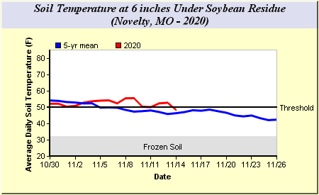
During the fall a chart of soil temperature at the 6 inch depth is available. This soil temperature is estimated for your latitude from the soil temperature probes at the MU Agricultural Weather Stations.
The soil temperature chart consists of a blue line of mean soil temperature and a red line of this year's soil temperature. The blue mean line is for as many years of data as are available for the agricultural weather station being used. The name of the station being used is in the graph heading. In order to give an indication of the trend in soil temperatures, the graph is for 2 weeks prior to the date of the report to 2 weeks into the future. The graph also indicates the critical decision points by using horizontal gray bars to indicate frozen soil and minimum planting temperatures.
Learn more about the Horizon Point reports